2024 News & Events
First-of-its-kind experiment illuminates wildfires in unprecedented detail
1 April 2024
adapted from the story by CIRES Communications
The groundbreaking study could lead to vast improvements in fire weather forecasting.
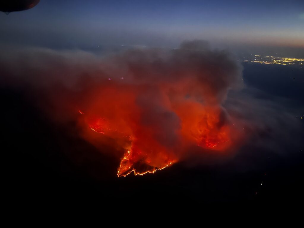
First results have been published from 2022's California Fire Dynamics Experiment (CalFiDE), a NOAA-led campaign to capture coordinated wildfire observations in real time.
The new study shows it's possible to collect measurements of fire and smoke chemistry, weather conditions, and smoke plume dynamics in real time around an active wildfire. The preliminary results are also shedding light on how pollutants like ozone are made and dispersed in a wildfire plume.
CalFiDE results could ultimately provide better forecasts for first responders on the ground who need to make quick decisions about firefighting strategy and evacuations, according to the researchers.
"We're able to learn a lot from this campaign because a lot of these observations have never been made," said Brian Carroll, a CIRES scientist working in NOAA CSL who led the new study detailing CalFiDE's first results. "Especially the structure of an updraft of a fire, how that's coupling to the intensity at the surface, and then linking that to some of the chemistry and air quality downwind."
A coordinated effort
Wildfire behavior is notoriously hard to predict, especially so in mountainous terrain like that of the American West. Forecasters use computer models to predict where a wildfire will spread and how intense it will get, but accurate forecasts need good observations and it's difficult to get close enough to observe a fire's behavior.
"Observations of active large wildfires are very rare," Carroll said. "It's really challenging to safely and properly measure conditions around a fire."
Researchers designed the CalFiDE mission to overcome those challenges by packing instruments onto a NOAA Twin Otter aircraft and on several pickup trucks. This allowed them to get close enough to take measurements from the air and on the ground while being mobile enough to stay safe and collect data from multiple locations.
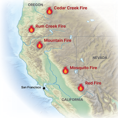
The NOAA Twin Otter flew repeated passes over five different wildfires in northern California and southern Oregon during August and September 2022, including the Mosquito Fire, California's largest wildfire that year. Researchers outfitted the aircraft with instruments to measure fire intensity and spread, wind profiles, and smoke plume chemistry.
Researchers drove the pickup trucks drove around the perimeter of the fires, collecting data on wind speed and air temperature while the Twin Otter was flying above. It's the first time these kinds of measurements have been taken together during active wildfires and required the researchers to coordinate closely with firefighters and other emergency management personnel.
"That had a whole new gravity to it and really drove home the importance of the work that we were doing," Carroll said.
Analyzing the data
Carroll and his colleagues are now analyzing the data and are already seeing some interesting results. Although the findings are preliminary, many of the measurements they captured are completely new.
The scientists are particularly interested in how ozone is produced in a wildfire plume. Ozone is a ground-level pollutant often made during wildfires, but the chemical reactions that produce it require sunlight. Carroll and his colleagues recorded high ozone concentrations in several of the fires they studied; they are trying to understand how ozone levels could get so high in a fire where a thick smoke plume blocks out nearly all the available sunlight.
CalFiDE observations are providing valuable input for forecasting models, according to Adam Kochanski, a wildfire researcher at San Jose State University who was involved in the campaign. CalFiDE data allows forecasters to evaluate whether their models accurately represent a fire's dynamics and how the fire interacts with the local weather.
"Is the rate of spread captured correctly? Do we compute correctly the amount of heat being produced by this fire?" Kochanski said. "That's why you need to have this comprehensive set of observations: if you miss even one of the components, everything breaks apart."
This project was partially funded by FY22 Disaster Relief Supplemental Appropriations (DRSA).
Carroll, B.J., W.A. Brewer, E. Strobach, N. Lareau, S.S. Brown, M.M. Valero, A. Kochanski, C.B. Clements, R. Kahn, K.T. Junghenn Noyes, A. Makowiecki, M.W. Holloway, M. Zucker, K. Clough, J. Drucker, K. Zuraski, J. Peischl, B. McCarty, R. Marchbanks, S. Sandberg, S. Baidar, Y.L. Pichugina, R.M. Banta, A. Klofas, B. Winters, and T. Salas, Measuring coupled fire-atmosphere dynamics: The California Fire Dynamics Experiment (CalFiDE), Bulletin of the American Meteorological Society, doi:10.1175/BAMS-D-23-0012.1, 2024.
Abstract
The social, economic, and ecological impacts of wildfires are increasing over much of the U.S. and globally, partially due to changing climate and build-up of fuels from past forest management practices. This creates a need to improve coupled fire-atmosphere forecast models. However, model performance is difficult to evaluate due to scarcity of observations for many key fire-atmosphere interactions, including updrafts and plume injection height, plume entrainment processes, fire intensity and rate-of-spread, and plume chemistry. Intensive observations of such fire-atmosphere interactions during active wildfires are rare due to the logistical challenges and scales involved. The California Fire Dynamics Experiment (CalFiDE) was designed to address these observational needs, using Doppler lidars, high-resolution multispectral imaging, and in-situ air quality instruments on a NOAA Twin Otter research aircraft, and Doppler lidars, radar, and other instrumentation on multiple ground-based mobile platforms. Five wildfires were studied across northern California and southern Oregon over 16 flight days from 28 August to 25 September 2022, including a breadth of fire stages from large blow-up days to smoldering air quality observations. Missions were designed to optimize the observation of the spatial structure and temporal evolution of each fire from early afternoon until sunset during multiple consecutive days. The coordination of the mobile platforms enabled four-dimensional sampling strategies during CalFiDE that will improve understanding of fire-atmosphere dynamics, aiding in model development and prediction capability. Satellite observations contributed aerosol measurements and regional context. This article summarizes the scientific objectives, platforms and instruments deployed, coordinated sampling strategies, and presents first results.